-

- Trade Leads
- Trade Services
- B2B Directories
- Trade Connections
- Misc
- Contact Us


A free import export trade leads B2B marketplace since 1996 for manufacturers, suppliers, exporters, importers, buyers, sellers, wholesalers, freight forwarders, shippers, trade shows, exhibits, and export management.
Hello visitor from USA - 86 visiting from 82 USA
  2 UK
2 UK  1 New Zealand
  1 Argentina
Hello visitor from
Dlgs Topographic Mapping
Posted at: Offers to Sell and Export | Posted on: Tuesday 16 August 2022 3:42 am | Poster last visit: Tuesday 16 August 2022 |
Product Category: Main
» Engineering and Research and Technology Based Services
» Earth science services
» Cartography
» Mapping
» Dlgs Topographic Mapping
Product Description:
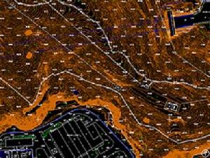
DLGs Topographic Mapping Supplier - Feiyan Technology
Sensor: DMC II-230
Flight platform: Cessna 208B
Height:
2300m
Resolution: 0.2m
Project area: 8, 500km²
Duration: 4 days
Output: DEM, orthophoto or video version
A topographic map is a type of map with a detailed representation of surface. The topographic map depicts ground relief (landforms and terrain), drainage (lakes and rivers), forest cover, transportation routes and facilities, governmental borders, populated areas and man-made objects.
Company Contact:

Contact Name: Frank Zhao
Company Name: Feiyan Aerial Remote Sensing Tech Co., Ltd.
Email:
Tel: 025-83216189
Fax: 025-83216189
Street Address: 450 S Taiping Rd
Siya Fortune Ctr, 8th Floor
Nanjing, Jiangsu 210008
China
Website: https://en.feiyantech.com/
Member name: feiyantech
Country: China
China
Member Since: 16 August 2022
Total Leads: 7 feiyantech Import Export Business Leads
Business focus: Aerial Photogrammetry, Lidar Data Acquisition, Dem, Orthophoto, Dsm Production
Chat:
Verify: Safe Import Export Tips
Sensor: DMC II-230
Flight platform: Cessna 208B
Height:
2300m
Resolution: 0.2m
Project area: 8, 500km²
Duration: 4 days
Output: DEM, orthophoto or video version
A topographic map is a type of map with a detailed representation of surface. The topographic map depicts ground relief (landforms and terrain), drainage (lakes and rivers), forest cover, transportation routes and facilities, governmental borders, populated areas and man-made objects.
Company Contact:
Contact Name: Frank Zhao
Company Name: Feiyan Aerial Remote Sensing Tech Co., Ltd.
Email:
Tel: 025-83216189
Fax: 025-83216189
Street Address: 450 S Taiping Rd
Siya Fortune Ctr, 8th Floor
Nanjing, Jiangsu 210008
China
Website: https://en.feiyantech.com/
Member name: feiyantech
Country:
Member Since: 16 August 2022
Total Leads: 7 feiyantech Import Export Business Leads
Business focus: Aerial Photogrammetry, Lidar Data Acquisition, Dem, Orthophoto, Dsm Production
Chat:
Verify: Safe Import Export Tips
 Similar Suppliers And Manufacturers Import Export Trade Leads
 3d Mapping Service - By feiyantech - On Tuesday 16 August 2022 3:41 am: mapping service
transportation network
water sewage pipelines
natural amp amp artificial drainage
land use plans
segregation of conflicting la....
3d Mapping Service - By feiyantech - On Tuesday 16 August 2022 3:41 am: mapping service
transportation network
water sewage pipelines
natural amp amp artificial drainage
land use plans
segregation of conflicting la.... Lidar Mapping Services - By feiyantech - On Tuesday 16 August 2022 3:38 am: topographic and bathymetric topographic lidar typically uses a near-infrared laser to map the land while bathymetric lidar uses water-penetrating gr....
 Supports Online Cheap Gis And Mapping - By ChongqingGoldCompany - On Friday 30 October 2015 6:23 am: mapping
with windows mobile 6 5 you may upload necessary utilities or software on your qmini m to suit your next job
you can collect gis gps poin....
Supports Online Cheap Gis And Mapping - By ChongqingGoldCompany - On Friday 30 October 2015 6:23 am: mapping
with windows mobile 6 5 you may upload necessary utilities or software on your qmini m to suit your next job
you can collect gis gps poin.... Over Two Hundred Channels China Made Brand Surveying And Mapping Gps - By ChongqingGoldCompany - On Tuesday 1 December 2015 7:29 am: mapping gps
it is designed to meet high quality standards at an affordable price it is outstanding in its
class with a rugged design and user-frie....
Over Two Hundred Channels China Made Brand Surveying And Mapping Gps - By ChongqingGoldCompany - On Tuesday 1 December 2015 7:29 am: mapping gps
it is designed to meet high quality standards at an affordable price it is outstanding in its
class with a rugged design and user-frie.... Demo Medical Eeg Series Digital Brain Electric Activity Mapping - By demomedical - On Monday 14 November 2016 3:00 am: demo medical eeg series digital brain electric activity mapping
demo medical eeg series digital brain electric activity mapping
performance parameter
numbers of channels 16 channels of eeg+2 channels of ecg ec....
Demo Medical Eeg Series Digital Brain Electric Activity Mapping - By demomedical - On Monday 14 November 2016 3:00 am: demo medical eeg series digital brain electric activity mapping
demo medical eeg series digital brain electric activity mapping
performance parameter
numbers of channels 16 channels of eeg+2 channels of ecg ec.... Automatic Mapping Cave Detector Pqwt-kd300 - By abitdrill - On Monday 23 September 2019 2:23 am: mapping cave detector is based on the earths electromagnetic field source based on the difference in the conductivity of different underground geolo....
 Automatic Mapping Water Detector - By abitdrill - On Monday 23 September 2019 2:27 am: mapping water detector uses the earth s magnetic field to measure stratum structure
through the analysis of stratum structure the groundwater outle....
Automatic Mapping Water Detector - By abitdrill - On Monday 23 September 2019 2:27 am: mapping water detector uses the earth s magnetic field to measure stratum structure
through the analysis of stratum structure the groundwater outle.... Automatic Mapping Water Detector Pqwt-tc150 - By abitdrill - On Monday 23 September 2019 2:28 am: mapping water detector is based on the earth s electromagnetic field as the field source based on the difference in the conductivity of different und....
 Mapping Classification Navigation
Main - Engineering and Research and Technology Based Services - Earth science services - Cartography - Mapping [6]
TradersCity.com shall not be held liable for any user posted/submitted content including but not limited to trade leads, profiles, images, and any other data. TradersCity.com does not and did not verify any of users posted/submitted data nor is implicitly or explicitly recommending these business offers. TradersCity does not verify truthfulness, accuracy, completeness, nor legality of any businesses, services, and leads posted here. TradersCity does not represent Sellers or Buyers in any transaction between users of the website and is unable to make any opinion in regard to their performance in any transaction. TradersCity neither guarantees nor undertakes in any dispute between sellers and buyers. Protect your business from fraud by trading safely